Winter Wheat Planting Information Extraction Based on Principal Component and Cloud Model
-
摘要:
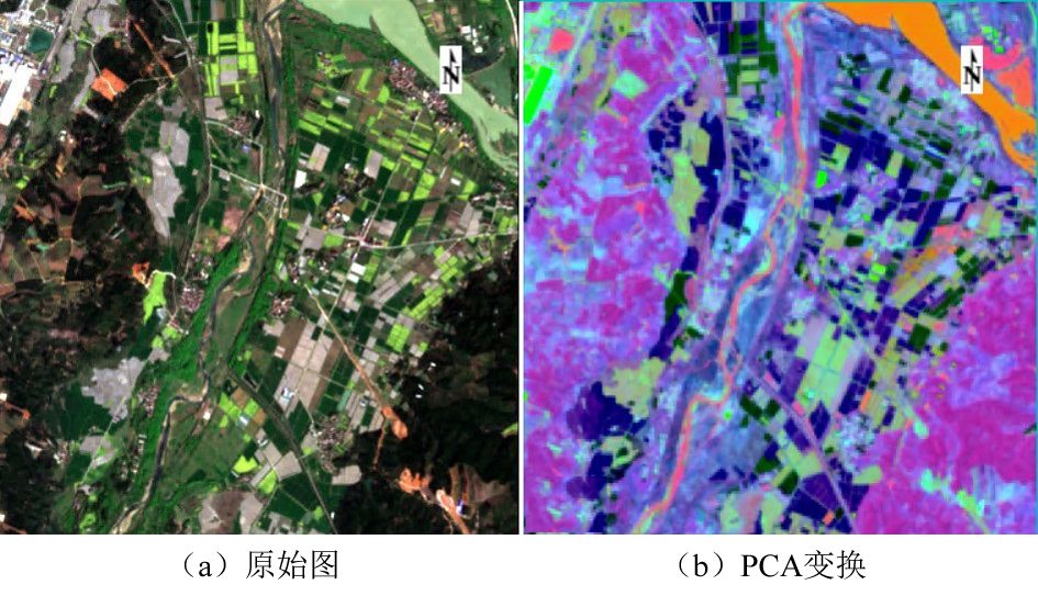
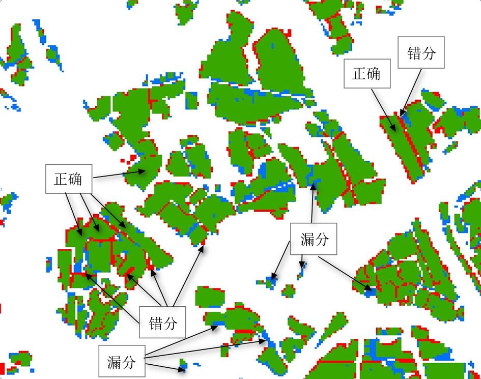
在对Sentinel-2卫星遥感影像进行预处理的基础上,利用主成分变化提取小麦主要信息,基于云模型算法开展光谱遥感图像分类。分类时,首先根据训练样本集,由逆向云发生器生成典型小麦的云模型,然后利用云发生器计算出各波段每个象元对小麦地物的平均隶属度,在对各波段的隶属度分析基础上,摒弃含有复杂信息的第1主成分,利用第2主成分和第3主成分信息实现对冬小麦种植空间信息的提取。结果表明,提取小麦种植信息制图精度和用户精度分别为92.78%和99.90%,小麦种植田块的隶属度值因小麦长势和密度的不同有较大的差异,云模型对长势较差、密度较低的小麦像元存在漏分现象。基于云模型的算法精度极高,对小麦地块的识别错分、漏分现象少。该模型有助于冬小麦种植面积的精确提取,对于农业部门进行冬小麦生长监测与产量估测有重要的支撑作用。
Abstract:Based on preprocessing of Sentinel-2 satellite remote sensing images, main information of wheat was extracted by principal component changes, and then a spectral remote sensing image classification method based on cloud model was applied.When classifying, firstly, according to training sample set, cloud model of typical wheat was generated by reverse cloud generator, and then cloud generator was used to calculate average membership degree of each pixel in each band to wheat ground features.On basis of analysis, the first principal component containing complex information was discarded, and the second and third principal component information was used to extract spatial information of winter wheat planting.Results showed that mapping accuracy and user accuracy of extracting wheat planting information were 92.78% and 99.90%, respectively.Membership value of wheat planting fields had great differences due to difference of wheat growth and density.Cloud model of poor growth and density, which resulted in low wheat pixels, had phenomenon of missing points.In general, algorithm based on cloud model was highly accurate, and there were few misclassifications and omissions in identification of wheat field.Algorithm would play an important supporting role in agricultural sector for winter wheat growth monitoring and yield estimation.
-
Keywords:
- principal component /
- cloud model /
- wheat /
- planting information
-
表 1 哨兵-2A 光谱波段信息
Table 1. Sentinel-2A spectral band information
波段 波长/μm 分辨率/m Band2(蓝光) 0.490 10 Band3(绿光) 0.560 10 Band4(红光) 0.665 10 Band5(红边1) 0.705 20 Band6(红边1) 0.740 20 Band7(红边1) 0.783 20 Band8(近红外) 0.842 10 Band8A(红边4) 0.865 20 Band11(短波红外1) 1.614 20 Band12(短波红外2) 2.202 20  下载: 导出CSV
表 2 主成分协方差特征向量矩阵及统计分析
Table 2. Principal component covariance eigenvector matrix and statistical analysis
项目 PC1 PC2 PC3 PC4 PC5 PC6 PC7 PC8 PC9 PC10 Band2 −0.018 0.321 −0.287 −0.122 −0.582 −0.115 0.328 0.093 −0.154 −0.555 Band3 −0.041 0.316 −0.426 −0.081 −0.159 0.209 0.314 −0.283 0.015 0.680 Band4 −0.037 0.441 −0.360 −0.022 0.106 0.324 −0.670 0.021 0.263 −0.198 Band5 −0.111 0.350 −0.235 0.237 0.566 −0.234 0.195 0.453 −0.368 0.023 Band6 −0.390 −0.034 −0.132 0.359 0.263 −0.097 0.324 −0.420 0.504 −0.292 Band7 −0.469 −0.151 −0.117 0.313 −0.208 −0.155 −0.375 −0.341 −0.564 0.048 Band8 −0.529 −0.166 −0.112 −0.791 0.217 −0.066 0.013 0.028 −0.022 −0.043 Band8A −0.499 −0.152 0.046 0.253 −0.332 0.234 0.023 0.622 0.269 0.192 Band11 −0.245 0.401 0.588 −0.015 0.087 0.544 0.172 −0.155 −0.247 −0.120 Band12 −0.153 0.494 0.400 −0.073 −0.163 −0.629 −0.174 −0.025 0.255 0.222 特征值 2701053.3 463642.1 197268.0 41346.4 18464.4 6353.0 4798.2 3807.2 3143.7 2354.6 贡献率 0.785 0.135 0.057 0.012 0.005 0.002 0.001 0.001 0.001 0.001 累计贡献率 0.785 0.919 0.977 0.989 0.994 0.996 0.997 0.998 0.999 1.000
下载: 导出CSV
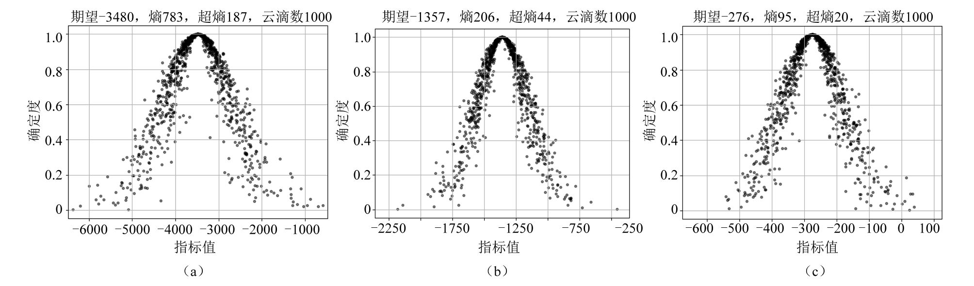
表 3 主成分图像云模型参数
Table 3. Principal component image cloud model parameters
模型参数 PC1 PC2 PC3 $ {E}_{x} $ −3480 −1357 −276 $ {E}_{n} $ 783 206 95 $ {H}_{e} $ 187 44 20 CD 0.72 0.64 0.63
下载: 导出CSV
-
[1] 吴炳方, 张淼, 曾红伟, 等.大数据时代的农情监测与预警[J].遥感学报, 2016, 20(5): 1 027-1 037.WU Bingfang, ZHANG Miao, ZENG Hongwei, et al.Agricultural monitoring and early warning in the era of big data [J].Journal of Remote Sensing, 2016, 20(5): 1 027-1 037. [2] 陈仲新,任建强,唐华俊,等.农业遥感研究应用进展与展望[J].遥感学报,2016,20(5):748-767.CHEN Zhongxin,REN Jianqiang,TANG Huajun,et al.Progress and prospectives on agricultural remote sensing research and applications in China[J].Journal of Remote Sensing,2016,20(5):748-767. [3] 史舟,梁宗正,杨媛媛,等.农业遥感研究现状与展望[J].农业机械学报,2015,46(2):247-260. doi: 10.6041/j.issn.1000-1298.2015.02.037SHI Zhou,LIANG Zongzheng,YANG Yuanyuan,et al.Status and prospect of agricultural remote sensing[J].Transactions of the Chinese Society for Agricultural Machinery,2015,46(2):247-260. doi: 10.6041/j.issn.1000-1298.2015.02.037 [4] 程永政.多尺度农作物遥感监测方法及应用研究[D].南京: 解放军信息工程大学, 2009.CHENG Yongzheng.The study on the methods for multi-scale crop monitoring by remote sensing [D].Nanjing: PLA University of Information Engineering, 2009. [5] 段春华,张汛,尹凡.基于国产高分卫星影像的水稻种植区提取:以江苏苏中地区为例[J].卫星应用,2021(2):59-64. doi: 10.3969/j.issn.1674-9030.2021.02.013 [6] 王霄煜,雷钧.基于高分一号卫星数据的新疆棉花种植面积信息提取研究[J].新疆农业科技,2021(1):23-26. doi: 10.3969/j.issn.1007-3574.2021.01.011 [7] 薛宇飞,张军,张萍,等.基于Sentinel-2遥感影像的烟草种植信息精准提取[J].中国烟草科学,2022,43(1):96-106. doi: 10.13496/j.issn.1007-5119.2022.01.015XUE Yufei,ZHANG Jun,ZHANG Ping,et al.Object-oriented accurate extraction of tobacco information based on sentinel-2 remote sensing images[J].China Tobacco Science,2022,43(1):96-106. doi: 10.13496/j.issn.1007-5119.2022.01.015 [8] 王朝阳,师银芳,侯诚.基于Sentinel-2A影像的枸杞种植区域识别[J].生态学杂志,2022,41(5): 1033- 1040. doi: 10.13292/j.1000-4890.202205.007WANG Chaoyang,SHI Yinfang,HOU Cheng.Recognition and extraction of planting area of Chinese wolfberry based on Sentinel-2A[J].Chinese Journal of Ecology,2022,41(5): 1033 - 1040. doi: 10.13292/j.1000-4890.202205.007 [9] 王爱芳,张运,黄静,等.作物遥感分类研究进展[J].测绘与空间地理信息,2021,44(10):80- 83,88. doi: 10.3969/j.issn.1672-5867.2021.10.021WANG Aifang,ZHANG Yun,HUANG Jing,et al.Recent progresses in research of crop classification by using remote sensing[J].Geomatics & Spatial Information Technolog,2021,44(10):80- 83,88. doi: 10.3969/j.issn.1672-5867.2021.10.021 [10] 申怀飞.基于遥感多时相影像的南海北部湾地区地物分类与识别方法研究[D].南京: 南京大学, 2018.SHEN Huaifei.Research on the classification and recognization methods of objects based on multi-temporal remote sensing images in Beibu Gulf region of the South China Sea [D].Nanjing: Nanjing University, 2018. [11] 佘宝,黄敬峰,石晶晶,等.基于红边位置变化特征的油菜种植区域提取[J].农业工程学报,2013,29(15):145-152. doi: 10.3969/j.issn.1002-6819.2013.15.018SHE Bao,HUANG Jingfeng,SHI Jingjing,et al.Extracting oilseed rape growing regions based on variation characteristics of red edge position[J].Transactions of the Chinese Society of Agricultural Engineering,2013,29(15):145-152. doi: 10.3969/j.issn.1002-6819.2013.15.018 [12] 王冬利, 张安兵, 赵安周, 等.非监督分类的冬小麦种植信息提取模型[J].测绘通报, 2019(8): 68-71, 77.WANG Dongli, ZHANG Anbing, ZHAO Anzhou, et al.Extraction model of winter wheat planting information based on unsupervised classification [J].Bulletin of Surveying and Mapping, 2019(8): 68-71, 77. [13] 牟多铎,刘磊.ELM与SVM在高光谱遥感图像监督分类中的比较研究[J].遥感技术与应用,2019,34(1):115-124.MU Duoduo,LIU Lei.Comparative study of ELM and SVM in hyperspectral image supervision classification[J].Remote Sensing Technology and Application,2019,34(1):115-124. [14] 孙秀邦,范伟,严平,等.遥感影像土地覆被分类研究进展[J].中国农学通报,2007,23(9):607-610. doi: 10.3969/j.issn.1000-6850.2007.09.129SUN Xiubang,FAN Wei,YAN Ping,et al.A brief review on the classification methods of land cover based on remote sensing image[J].Chinese Agricultural Science Bulletin,2007,23(9):607-610. doi: 10.3969/j.issn.1000-6850.2007.09.129 [15] 王小明,毛梦祺,张昌景,等.基于支持向量机的遥感影像分类比较研究[J].测绘与空间地理信息,2013,36(4):17- 20,23. doi: 10.3969/j.issn.1672-5867.2013.04.005WANG Xiaoming,MAO Mengqi,ZHANG Changjing,et al.Comparative study on classification of remote seining image by support vector machine[J].Geomatics & Spatial Information Technology,2013,36(4):17- 20,23. doi: 10.3969/j.issn.1672-5867.2013.04.005 [16] 罗桓,李卫国,景元书,等.基于SVM的县域冬小麦种植面积遥感提取[J].麦类作物学报,2019,39(4):455-462. doi: 10.7606/j.issn.1009-1041.2019.04.11LUO Huan,LI Weiguo,JING Yuanshu,et al.Remote sensing extraction of county winter wheat planting area based on SVM[J].Journal of Triticeae Crops,2019,39(4):455-462. doi: 10.7606/j.issn.1009-1041.2019.04.11 [17] 周珂, 柳乐, 张俨娜, 等.GEE支持下的河南省冬小麦面积提取及长势监测[J].中国农业科学, 2021, 54(11): 2 302-2 318.ZHOU Ke, LIU Le, ZHANG Yanna, et al.Area extraction and growth monitoring of winter wheat in Henan province by Google Earth Engine [J].Scientia Agricultura Sinica, 2021, 54(11): 2 302-2 318. [18] 张国良.基于U-Net的葡萄种植区遥感影像变化检测[D].杨凌: 西北农林科技大学, 2021.ZHANG Guoliang.Remote sensing images change detection of grape plantation based on U-Net[D].Yangling: Northwest A&F University, 2021. [19] 刘戈, 姜小光, 唐伯惠.特征优选与卷积神经网络在农作物精细分类中的应用研究[J].地球信息科学学报, 2021, 23(6): 1 071-1 081.LIU Ge, JIANG Xiaoguang, TANG Bohui.Application of feature optimization and convolutional neural network in crop classification [J].Journal of Geo-Information Science, 2021, 23(6): 1 071-1 081. [20] 李德毅, 杜鹢.不确定性人工智能[M].北京: 国防工业出版社, 2014: 44-50. [21] 汪甜甜,费坤,江文娟,等.宣州区耕地质量等级评价及灌排能力对耕地质量影响[J].灌溉排水学报,2021,40(11):79-89. doi: 10.13522/j.cnki.ggps.2021126WANG Tiantian,FEI Kun,JIANG Wenjuan,et al.Soil quality classification and the impact of irrigation and drainage in the region of Xuanzhou in Anhui province[J].Journal of Irrigation and Drainage,2021,40(11):79-89. doi: 10.13522/j.cnki.ggps.2021126 [22] 王本文.自然资源管理概况[M]// 洪明祥.宣州年鉴.时代出版传媒股份有限公司黄山书社, 2020: 45-60. [23] 李煜,李崇贵,刘思涵,等.应用哨兵2A多时相遥感影像对树种的识别[J].东北林业大学学报,2021,49(3):44- 47,51. doi: 10.3969/j.issn.1000-5382.2021.03.008LI Yu,LI Chonggui,LIU Sihan,et al.Tree species recognition with Sentinel-2A multitemporal remote sensing image[J].Journal of Northeast Forestry University,2021,49(3):44- 47,51. doi: 10.3969/j.issn.1000-5382.2021.03.008 [24] 田野,赵春晖,季亚新.主成分分析在高光谱遥感图像降维中的应用[J].哈尔滨师范大学自然科学学报,2007,23(5):58-60.TIAN Ye,ZHAO Chunhui,JI Yaxin.The principal component analysis applied to hyperspectral remote sensing imagedimensional reduction[J].Natural Science Journal of Harbin Normal University,2007,23(5):58-60. [25] 邓广林,邵美珍.遥感图像分析中的主成分分析[J].遥感信息,1989(4):13- 16,53. [26] 刘常昱,李德毅,潘莉莉.基于云模型的不确定性知识表示[J].计算机工程与应用,2004,40(2):32-35. doi: 10.3321/j.issn:1002-8331.2004.02.011LIU Changyu,LI Deyi,PAN Lili.Uncertain knowledge representation based on cloud model[J].Computer Engineering and Applications,2004,40(2):32-35. doi: 10.3321/j.issn:1002-8331.2004.02.011 [27] 周婷, 邹俊, 崔玉环, 等.基于主成分分析和支持向量机的遥感影像水体提取方法及应用[J/OL].水资源保护.http://kns.cnki.net/kcms/detail/32.1356.TV.20220407.1836.006.html.ZHOU Ting, ZOU Jun, CUI Yuhuan, et al.PCA-SVM based water area extraction method for remote sensing images and its application in Chaohu Lake[J/OL].Water Resources Protection.http://kns.cnki.net/kcms/detail/32.1356.TV.20220407.1836.006.html. [28] 辛文杰, 马姜明, 王永琪.基于遥感生态指数的桂林市生态环境质量评价[J/OL].广西师范大学学报(自然科学版).https://doi.org/10.16088/j.issn.1001-6600.2021101004.XIN Wenjie, MA Jiangming, WANG Yongqi.Eco-environmental quality assessment of Guilin city based on remote sensing ecological index[J/OL].Journal of Guangxi Normal University (Natural Science Edition), https://doi.org/10.16088/j.issn.1001-6600.2021101004. [29] 黄振兴,李满根,封志兵,等.基于遥感生态指数的生态环境质量变化分析:以抚州市东乡区为例[J].东华理工大学学报(自然科学版),2022,45(1):60-66. doi: 10.3969/j.issn.1674-3504.2022.01.008HUANG Zhenxing,LI Mangen,FENG Zhibing,et al.Ecological environment change in Dongxiang district based on remote sensing ecological index[J].Journal of East China Institute of Technology (Natural Science Edition),2022,45(1):60-66. doi: 10.3969/j.issn.1674-3504.2022.01.008 [30] 马战林,薛华柱,刘昌华,等.基于主被动遥感数据和面向对象的大蒜识别[J].农业工程学报,2022,38(2):210-222. doi: 10.11975/j.issn.1002-6819.2022.02.024MA Zhanlin,XUE Huazhu,LIU Changhua,et al.Garlic Identification of garlic based on active and passive remote sensing data and object-oriented technology[J].Transactions of the Chinese Society of Agricultural Engineering,2022,38(2):210-222. doi: 10.11975/j.issn.1002-6819.2022.02.024 -

 下载:
下载:

 点击查看大图

计量
- 文章访问数: 37
- HTML全文浏览量: 9
- PDF下载量: 10
- 被引次数: 0
 京公网安备 11010502037498号