Ecological Risk Assessment of Gansu Section of Weihe River Basin Based on Landscape Pattern
-
摘要:
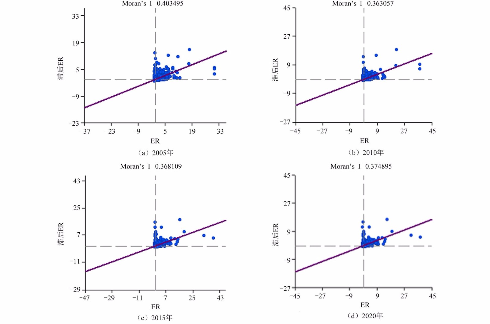
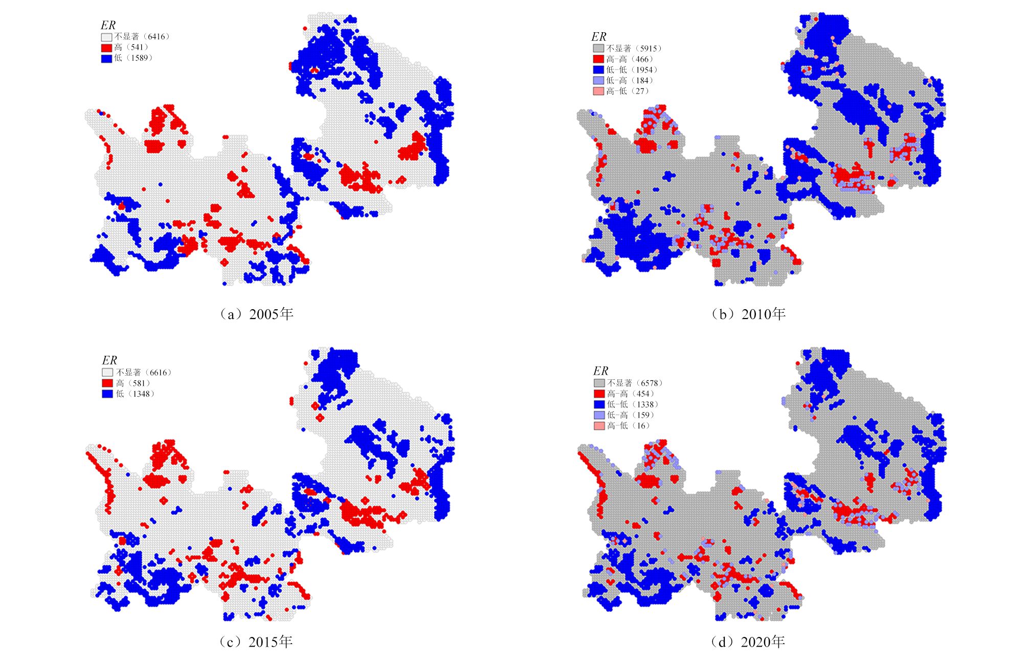
为揭示渭河流域甘肃段近16年来景观对生态风险的影响,以2005、2010、2015和2020年4期TM遥感影像为数据源,构建景观生态风险评价模型,开展渭河流域景观生态风险评价及其时空分异研究。结果表明:2005—2020年,研究区景观类型发生了较大变化,人为因素对景观类型的干扰较大;2005-2020年,各渭河流域甘肃段景观破碎度、分离度及干扰度除建设用地外均呈现增长趋势,景观分维数除建设用地外均呈现减少趋势;2005-2020年,渭河流域甘肃段景观生态风险空间分布呈现显著正相关性;渭河流域甘肃段以理想和良好生态风险区为主,占流域面积62%以上,较差生态风险区主要分布在定西市安定区。从整体来看,研究区生态风险呈现出稳定的趋势。
Abstract:In order to reveal impact of landscape on ecological risk in Gansu section of Weihe River Basin in recent 16 years, taking four TM remote sensing images in 2005, 2010, 2015 and 2020 as data sources, a landscape ecological risk assessment model was constructed and research on landscape ecological risk assessment and its temporal and spatial differentiation in Weihe River Basin were carried out.Results showed that, from 2005 to 2020, landscape types in study area had changed greatly, and human factors had a great interference on landscape types.From 2005 to 2020, landscape fragmentation, separation and interference in Gansu section of Weihe River Basin showed an increasing trend except for construction land, and landscape fractal dimension showed a decreasing trend except for construction land.From 2005 to 2020, spatial distribution of landscape ecological risk in Gansu section of Weihe River Basin showed a significant positive correlation.Gansu section of Weihe River Basin was dominated by ideal and good ecological risk areas, accounting for more than 62% of basin area.The poor ecological risk areas were mainly distributed in Anding District of Dingxi.On the whole, ecological risk in study area showed a stable trend.
-

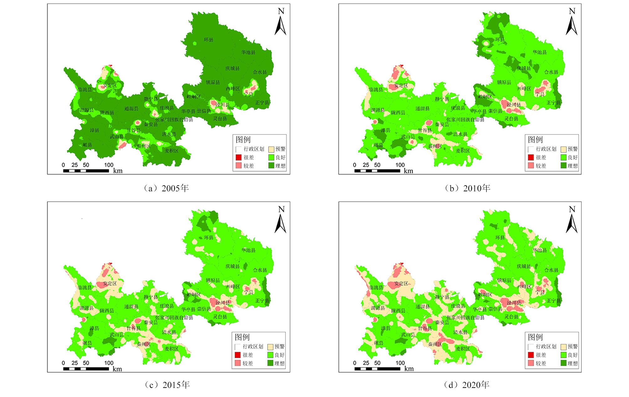
图 1 2005—2020年渭河流域生态风险分布
Figure 1. Distribution of ecological risk in Weihe River Basin from 2005 to 2020
表 1 景观指数计算方法及意义
Table 1. Calculation method and significance of landscape index
景观指数 计算方法及意义 景观破碎度指数(Ci) $ {C}_{i}=\dfrac{{n}_{i}}{{A}_{i}} $,$ {C}_{i} $>0 分离度指数(Ni) $ {N}_{i}={l}_{i}\times A/{A}_{i} $,${l}_{i}=\dfrac{1}{2}\sqrt{\dfrac{ {n}_{i} }{A} }$,$ {N}_{i} $>0 分维数(Fi) $ {F}_{i}=2{l}_{n}({P}_{i}/4)/{l}_{n}\left(A\right) $,Fi的值域为1~2 景观干扰度指数(Si) $ {S}_{i}=a{C}_{i}+b{N}_{i}+c{F}_{i} $,借鉴其他学者的研究,a、b、c分别为0.5、0.3和0.2 景观脆弱度指数(Vi) 对6种景观类型脆弱度指数赋值为未利用地6、水域5、耕地4、草地3、林地2、建设用地1,归一化后得到Vi 景观损失度指数(Ri) $ {R}_{i}={S}_{i}\times {V}_{i} $ 注:ni为景观类型i的斑块数;Ai为景观类型i的总面积;A为研究区景观总面积;Pi为景观类型i的周长。  下载: 导出CSV
表 2 景观类型分离度及景观损失指数
Table 2. Separation degree and landscape loss index of landscape types
景观 年份 面积/hm2 斑块数目 分维数 破碎度指数 分离度指数 干扰度指数 脆弱度指数 损失度指数 建设用地 2005 765 4954 1.053 6.479 12.346 3.938 0.0476 0.188 2010 823 4796 1.056 5.827 11.285 6.511 0.0476 0.310 2015 942 5038 1.062 5.349 10.108 5.912 0.0476 0.282 2020 1113 10185 1.069 9.153 12.165 8.440 0.0476 0.402 林地 2005 18021 12103 1.116 0.672 0.819 0.540 0.0952 0.049 2010 17525 11846 1.116 0.676 0.833 0.811 0.0952 0.077 2015 17607 12440 1.114 0.707 0.850 0.831 0.0952 0.079 2020 17582 12716 1.113 0.723 0.860 0.842 0.0952 0.080 草地 2005 23287 15639 1.131 0.672 0.720 0.490 0.1429 0.073 2010 22071 15730 1.130 0.713 0.762 0.811 0.1429 0.116 2015 22928 16681 1.126 0.728 0.756 0.816 0.1429 0.117 2020 22887 17248 1.124 0.754 0.770 0.833 0.1429 0.119 耕地 2005 28809 7855 1.121 0.273 0.413 0.443 0.1905 0.084 2010 30593 7732 1.120 0.253 0.386 0.466 0.1905 0.089 2015 29557 8688 1.115 0.294 0.423 0.497 0.1905 0.095 2020 29448 9746 1.111 0.331 0.450 0.523 0.1905 0.010 水域 2005 855 924 1.173 1.081 4.770 1.785 0.2381 0.425 2010 791 1009 1.165 1.276 5.389 2.487 0.2381 0.592 2015 786 1655 1.151 2.107 6.946 3.367 0.2381 0.802 2020 781 2016 1.143 2.581 7.710 3.832 0.2381 0.912 未利用地 2005 229 575 1.115 2.508 14.028 4.574 0.2857 1.307 2010 168 458 1.115 2.720 17.047 6.697 0.2857 1.913 2015 154 428 1.112 2.784 18.051 7.030 0.2857 2.008 2020 158 536 1.107 3.389 19.637 7.807 0.2857 2.231
下载: 导出CSV
表 3 渭河流域景观生态风险等级面积及比例
Table 3. Area and proportion of landscape ecological risk level in Weihe River Basin
生态风险等级 2005年 2010年 2015年 2020年 面积/km2 比例/% 面积/km2 比例/% 面积/km2 比例/% 面积/km2 比例/% 理想 59992 83.37 8424 11.71 3248 4.51 1589 2.21 良好 9047 12.57 30064 75.11 52835 73.43 45319 62.98 预警 2400 3.34 7785 10.82 14021 19.49 21648 30.09 较差 506 0.70 1688 2.35 1839 2.56 3383 4.70 很差 10 0.01 16 0.02 13 0.02 16 0.02
下载: 导出CSV
-
[1] 吕红亮,周霞,张文新,等.基于土地利用变化的长江经济带生态风险研究[J].北京师范大学学报(自然科学版),2021,57(4):517-523. doi: 10.12202/j.0476-0301.2020090LV Hongliang,ZHOU Xia,ZHANG Wenxin,et al.Ecological risks associated with changes in land use in the Yangtze River Economic Belt[J].Journal of Beijing Normal University (Natural Science Edition),2021,57(4):517-523. doi: 10.12202/j.0476-0301.2020090 [2] 孙桂丽,王立,李雪,等.2000—2015年吐鲁番市高昌区景观格局及生态风险变化分析[J].江西农业学报,2021,33(8):78-86.SUN Guili,WANG Li,LI Xue,et al.Analysis of landscape pattern and ecological risk change in Gaochang District,Turpan City from 2000 to 2015[J].Acta Agriculturae Jiangxi's,2021,33(8):78-86. [3] SOLOVJOVA N V.Ecological risk simulation assessment in marine ecosystems of the arctic shelf[J].Marine Pollution Bulletin, 2021.DOI: 10.1016/J.MARPOLBUL.2021.112577. [4] LIU Pei, ZHANG Xiaoying, MA Chao, et al.Ecological security assessment based on remote sensing and landscape ecology model[J].Journal of Sensors, 2021.DOI: 10.1155/2021/6684435. [5] KE Xiaoling, WANG Xingyue, GUO Haixiang, et al.Urban ecological security evaluation and spatial correlation research: based on data analysis of 16 cities in Hubei Province of China[J].Journal of Cleaner Production, 2021.DOI: 10.1016/J.JCLEPRO.2021.127613. [6] 李坤洋,杜营彬,鲁琳.基于GIS的生态敏感性评价与山体修复策略:以青海同仁市隆务西山为例[J].湖南生态科学学报,2021,8(4):72-83. doi: 10.3969/j.issn.2095-7300.2021.04.011LI Kunyang,DU Yingbin,LU Lin.Ecological sensitivity evaluation and mountain restoration strategy based on GIS:a case study of Longwu West Mountain in Tongren City,Qinghai Province[J].Journal of Hunan Ecological Science,2021,8(4):72-83. doi: 10.3969/j.issn.2095-7300.2021.04.011 [7] 谢波,梁若冰.基于PSR模型的云南省生态安全评价研究[J].昆明理工大学学报(社会科学版),2021,21(6):80-87.XIE Bo,LIANG Ruobing.Ecological security evaluation study in Yunnan Province based on PSR model[J].Journal of Kunming University of Science and Technology (Social Sciences Edition),2021,21(6):80-87. [8] 王硕.渭河流域综合生态风险评价[D].西安: 陕西师范大学, 2019. [9] 曾建军,邹明亮,郭建军,等.生态风险评价研究进展综述[J].环境监测管理与技术,2017,29(1):1- 5,10. doi: 10.3969/j.issn.1006-2009.2017.01.001ZENG Jianjun,ZOU Liangming,GUO Jianjun,et al.Ecological risk assessment and its research progress[J].The Administration and Technique of Environmental Monitoring,2017,29(1):1- 5,10. doi: 10.3969/j.issn.1006-2009.2017.01.001 [10] 阳文锐,王如松,黄锦楼,等.生态风险评价及研究进展[J].应用生态学报,2007,18(8): 1869- 1876. doi: 10.13287/j.1001-9332.2007.0292YANG Wenrui,WANG Rusong,HUANG Jinlou,et al.Ecological risk assessment and its research progress[J].Chinese Journal of Applied Ecology,2007,18(8): 1869 - 1876. doi: 10.13287/j.1001-9332.2007.0292 [11] XU Tong,ZHANG Miao,GAO Lijie,et al.Development and application of a comprehensive ecological risk assessment indicator system in Xiamen,China[J].International Journal of Sustainable Development & World Ecology,2018,25(5):468-476. [12] 原伟鹏,刘新平,陈玉.耕地面源污染的生态风险评价指标体系探讨与防控:以新疆昌吉州为例[J].中南林业科技大学学报(社会科学版),2019,13(2):35-42.YUAN Weipeng,LIU Xinping,CHEN Yu.Discussion on ecological risk evaluation index system of non-point source pollution of cultivated land and its prevention and control:taking Changji Hui Autonomous Prefecture of Xinjiang as an example[J].Journal of Central South University of Forestry and Technology (Social Science Edition),2019,13(2):35-42. [13] 郭杰,王珂,于琪,等.长江中游近岸表层沉积物重金属污染特征分析及风险评估[J].环境科学学报,2021,41(11): 4625- 4636. doi: 10.13671/j.hjkxxb.2021.0317GUO Jie,WANG Ke,YU Qi,et al.Pollution characteristics of the heavy metals and their potential ecological risk assessment in nearshore sediments of the middle reaches of the Yangtze River[J].Acta Scientiae Circumstantiae,2021,41(11): 4625 - 4636. doi: 10.13671/j.hjkxxb.2021.0317 [14] 段续川,李苹,黄勇,等.北京市密云区农业土壤重金属元素地球化学特征及生态风险评价[J].现代地质,2018,32(1):95-104. doi: 10.19657/j.geoscience.1000-8527.2018.01.09DUAN Xuchuan,LI Ping,HUANG Yong,et al.Geochemical characteristics and risk assessment of heavy metals in agricultural soils in Miyun District of Beijing[J].Geoscience,2018,32(1):95-104. doi: 10.19657/j.geoscience.1000-8527.2018.01.09 [15] 刘昕宇, 李逸, 张荧, 等.珠江干流毒害性有机污染物的筛查与生态风险评价研究[C]//中国水利学会2016学术年会论文集(上册): 河海大学出版社, 2016: 432-438. [16] MA Long, MA Long, ZHANG Ying, et al.Study on application of regional ecological risk assessment during the development and utilization of Chu Island[J].Iop Conference Series: Earth and Environmental Science, 2020.DOI: 10.1088/1755-1315/558/4/042046. [17] 岳启发,赵筱青,李思楠,等.“一带一路”背景下博多河流域景观格局变化及生态风险评价研究[J].世界地理研究,2021,30(4):839-850. doi: 10.3969/j.issn.1004-9479.2021.04.2020082YUE Qifa,ZHAO Xiaoqing,LI Sinan,et al.Landscape pattern changes and ecological risk in the Padam River Basin under the background of the "Belt and Road" Initiative[J].World Regional Studies,2021,30(4):839-850. doi: 10.3969/j.issn.1004-9479.2021.04.2020082 [18] 杜嵩.基于土地利用变化的西安市景观生态风险评价研究[D].西安: 西安科技大学, 2021.DU Song.Reasearch on landscape ecological risk assessment of Xi'an City based on land use change[D].Xi'an: Xi'an University of Science and Technology, 2021. [19] 李思佳.山西省泽州县土地利用生态风险评价研究[D].北京: 中国地质大学(北京), 2020.LI Sijia.Research on ecological risk assessment of land use in Zezhou County, Shanxi Province[D].Beijing: China University of Geosciences (Beijing), 2020. [20] GUO Kai,XI Kuai,CHEN Yiyun,et al.Risk assessment of land ecology on a regional scale:application of the relative risk model to the Mining City of Daye,China[J].Human and Ecological Risk Assessment:An International Journal,2017,23(3):550-574. doi: 10.1080/10807039.2016.1255137 [21] 尉芳, 刘京, 夏利恒, 等.基于LUCC的陕西渭北旱塬区景观生态风险评价[J].中国环境科学: 1-12.https://doi.org/10.19674/j.cnki.issn1000-6923.20220112.002.WEI Fang, LIU Jing, XIA Liheng, et al.Landscape ecological risk assessment of Weibei dryland region of Shaanxi Province based on LUCC[J].China Environmental Science: 1-12.https://doi.org/10.19674/j.cnki.issn1000-6923.20220112.002. [22] 杜华明.北方农牧交错带景观生态风险评价及格局优化研究[J].河北师范大学学报(自然科学版),2022,46(1):94-102.DU Huaming.Study on landscape ecological risk assessment and landscape pattern optimization of farming-pastoral ecotone in Northern China[J].Journal of Hebei Normal University (Natural Science Edition),2022,46(1):94-102. [23] 李婷,王志芳,高伟明.基于景观格局的河北省月岛生态风险评价[J].海洋湖沼通报,2021,43(6):169-178. doi: 10.13984/j.cnki.cn37-1141.2021.06.023LI Ting,WANG Zhifang,GAO Weiming.Ecological risk assessment of moon island in hebei province based on landscape pattern[J].Transactions of Oceanology and Limnology,2021,43(6):169-178. doi: 10.13984/j.cnki.cn37-1141.2021.06.023 [24] XIE Hualin, WEN Jiaming, CHEN Qianru, et al.Evaluating the landscape ecological risk based on GIS: a case‐study in the Poyang Lake Region of China[J].Land Degradation & Development, 2021.DOI: 10.1002/ldr.3951. [25] ZHANG W, CHANG W J, ZHU Z C, et al.Landscape ecological risk assessment of chinese coastal cities based on land use change[J].Applied Geography, 2020.DOI: 10.1016/j.apgeog.2020.102174. [26] PENG Tian, CAO Luodan, LI Jialin, et al.Landscape characteristics and ecological risk assessment based on multi-scenario simulations: a case study of Yancheng Coastal Wetland, China[J].Sustainability, 2020.DOI: 10.3390/su13010149. [27] 巩杰,谢余初,赵彩霞,等.甘肃白龙江流域景观生态风险评价及其时空分异[J].中国环境科学,2014,34(8): 2153- 2160.GONG Jie,XIE Yuchu,ZHAO Caixia,et al.Landscape ecological risk assessment and its spatiotemporal variation of the Bailongjiang watershed,Gansu[J].China Environmental Science,2014,34(8): 2153 - 2160. [28] 奚世军,安裕伦,李阳兵,等.基于景观格局的喀斯特山区流域生态风险评估:以贵州省乌江流域为例[J].长江流域资源与环境,2019,28(3):712-721.XI Shijun,AN Yulun,LI Yangbing,et al.Ecological risk assessment of karst mountain watershed based on landscape pattern:a case study of Wujiang River Basin in Guizhou Province[J].Resources and Environment in the Yangtze River Basin,2019,28(3):712-721. [29] 李峥.梁野山国家级自然保护区景观生态风险评价[J].武夷学院学报,2020,38(12):1-7. doi: 10.14155/j.cnki.35-1293/g4.2020.12.001LI Zheng.Landscape ecological risk assessment of Liangyeshan National Nature Reserve[J].Journal of Wuyi University,2020,38(12): 1 -7. doi: 10.14155/j.cnki.35-1293/g4.2020.12.001 [30] 潘竟虎,刘晓.疏勒河流域景观生态风险评价与生态安全格局优化构建[J].生态学杂志,2016,35(3):791-799. doi: 10.13292/j.1000-4890.201603.022PAN Jinghu,LIU Xiao.Landscape ecological risk assessment and landscape security pattern optimization in Shule River Basin[J].Chinese Journal of Ecology,2016,35(3):791-799. doi: 10.13292/j.1000-4890.201603.022 [31] 钟艳霞,崔文斌,罗玲玲,等.基于景观格局的宁夏星海湖生态风险时空分异[J].广西师范大学学报(自然科学版),2021,39(2):154-161.ZHONG Yanxia,CUI Wenbin,LUO Lingling,et al.Spatial and temporal variation of ecological risk of Xinghai Lake in Ningxia based on landscape pattern[J].Journal of Guangxi Normal University (Natural Science Edition),2021,39(2):154-161. [32] 白舒婷.基于土地利用变化的吉林西部景观生态风险评价研究[D].长春: 吉林大学, 2019.BAI Shuting.Study on landscape ecological risk assessment of western Jilin based on land use change[D].Changchun: Jilin University, 2019. [33] YANG Xinyi,WANG Lin,WU Tong,et al.Ecological risk assessment based on road network development analysis of Xiamen City,China[J].International Journal of Sustainable Development & World Ecology,2018,25(5):458-467. [34] 刘存东.基于景观格局的城市流域景观生态风险评价: 以重庆市清水溪流域为例[D].重庆: 重庆师范大学, 2010.LIU Cundong.Regional landscape ecological risk assessment of citywatershed based on landscape pattern: a case study of Qingshui Stream[D].Chongqing: Chongqing Normal University, 2010. [35] 昝旺.基于土地利用动态变化的区域景观生态风险时空分异研究: 以西昌市为例[D].成都: 四川师范大学, 2016.ZAN Wang.Study on spatial-temporal differentiation ofregional landscape ecological risk based onland use dynamic change: take Xichang Cityas an example[D].Chengdu: Sichuan Normal University, 2016. [36] 何莎莎,李欣,何春龙,等.基于土地利用变化的扬州市广陵区景观生态风险评价[J].南京师大学报(自然科学版),2019,42(1):139-148.HE Shasha,LI Xin,HE Chunlong,et al.Landscape ecological risk assessment in Guangling District of Yangzhou City based on land use change[J].Journal of Nanjing Normal University (Natural Science Edition),2019,42(1):139-148. -

 下载:
下载:

 点击查看大图
计量
- 文章访问数: 45
- HTML全文浏览量: 8
- PDF下载量: 6
- 被引次数: 0
 京公网安备 11010502037498号